2026-05-27 13:49:00
“ENVIRONMENTAL HAZARDS IN ASIA-2nd”
CONFERENCE FIELDTRIP
July 31-August 03, 2026
Mogod-Ulziit-BatUlzii
MONGOLIA
*Please note that field trip details are subject to change.
Field Trip Fee: USD $100
The fee includes:
- Accommodation and food/drinks in the field (4 days/3 nights)
- Transportation
- Shared tents for camping
Please note: Shared tents will be provided for camping in the field. Participants are required to bring their own sleeping bag.
August is generally the best time to visit Mongolia in terms of weather, with mild daytime temperatures of around 25°C (77°F). Evenings and nights can be considerably cooler, so bringing a warm sweater or fleece is recommended. Although Mongolia enjoys many sunny days, occasional rain is possible. We recommend bringing a raincoat or waterproof jacket, as well as sturdy hiking boots suitable for outdoor terrain.
The 2026 Conference Fieldtrip will be held in Bulgan, Arkhangai and Uvurkhangai provinces, Mongolia, during July 31st - August 3rd, 2026, organized by the team under supervision of the Conference Organizing Committee.
The focal themes for the 2026 Fieldtrip are as follows (see the Fig. 1):
Environmental hazards: Quaternary geology, geomorphology and environmental changes; earthquakes; depositional environments; paleoenvironmental and paleoclimatic changes. Objectives: Mogod fault rupture (Site 1) and Tuleet fault.
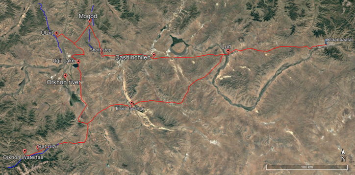
Fig.1. Route map Ulaanbaatar - Mogod - Ulziit
General schedule
July 31
|
Time
|
Activity
|
Location
|
Duration
|
Distance (from Ulaanbaatar)
|
|
06:00
|
Departure
|
-
|
-
|
-
|
|
07:00
|
Breakfast
|
Outside Ulaanbaatar city
|
30 min
|
~ 50km
|
|
09:30
|
Short stop
|
Lun soum
|
15 min
|
130 km
|
|
12:00
|
Lunchbox
|
Dashinchilen soum
|
1 hour
|
200 km
|
|
14:30
|
Short stop
|
The beginning of bumpy road
|
15 min
|
~ 280 km
|
|
16:00
|
Arrive
|
IAG camp, Mogod soum
|
-
|
~ 320 km
|
|
18:00
|
Dinner
|
IAG camp
|
2 hour
|
-
|
August 1
|
Time
|
Activity
|
Location
|
Duration
|
Distance
|
|
07:30
|
Breakfast
|
IAG camp
|
1 hour
|
-
|
|
08:30
|
Departure
|
Mogod rupture
|
-
|
-
|
|
12:30
|
Lunch
|
At the field
|
30 min
|
-
|
|
14:00
|
Visit
|
Tuleet fault
|
-
|
-
|
|
19:00
|
Dinner
|
IAG camp
|
2 hour
|
-
|
|
19:00
|
Firefestival
|
Small fire festival
|
-
|
-
|
* In the field - Observe co-seismic fault ruptures of the Mogod, January 4, 1967 M7 earthquake– strike slip and reverse faulting. Quaternary geology, geomorphology and environmental changes; earthquakes.
August 2
|
Time
|
Activity
|
Location
|
Duration
|
Distance (from Mogod soum)
|
|
07:00
|
Breakfast
|
IAG camp
|
1 hour
|
-
|
|
08:00
|
Departure
|
IAG camp
|
-
|
-
|
|
12:30
|
Lunch
|
Around Ugii Lake
|
15 min
|
~70 km
|
|
15:00
|
Visit
|
Orkhon valley
|
-
|
~150 km
|
|
17:00
|
Arrive
|
Tourist camp
|
-
|
-
|
* Field trip to south along the Orkhon river to observe Cenozoic volcanic field, canyon and waterfall. Volcanism, depositional environments; paleoenvironmental and paleoclimatic changes.
August 3
|
Time
|
Activity
|
Location
|
Duration
|
Distance
|
|
08:00
|
Breakfast
|
Tourist camp
|
1 hour
|
-
|
|
09:00
|
Departure
|
Orkhon Waterfall
|
-
|
-
|
|
14:00
|
Lunch
|
Elsen tasarhai sand dune
|
1 hour
|
360 km
|
|
17:00
|
Short stop
|
Urikhan Lun soum
|
15 min
|
510 km
|
|
19:30
|
Arrive
|
Ulaanbaatar city
|
-
|
640 km
|
BRIEF INTRODUCTION TO THE LOCALITIES AND OBJECTIVES
Site 1. Mogod fault rupture. The Mogod fault is one of the active faults in Mongolia, being the site of the 1967 Mogod earthquake. The Mogod fault has two N-S right-lateral strike-slip segments, which end in thrusts in a NW-SE fault at the southern end of the strike-slip fault.
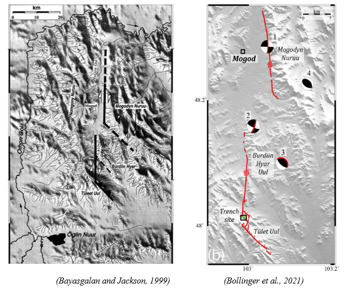
The 1967 Mogod earthquake M7, in Mogod provides important evidence about earthquake behavior in slowly deforming continental regions (SDCR). Although such regions are often thought to experience randomly distributed earthquakes, geological investigations reveal at least three major surface-rupturing earthquakes over the last 50,000 years along the same fault system, with an estimated slip rate of 0.06 ± 0.01 mm/year. These findings demonstrate that, similar to rapidly deforming regions, tectonic deformation in SDCR is concentrated along specific faults.
General. The South Khangai Volcanic Region (SKVR) is a widespread volcanic province in southern and central Mongolia, formed through 13 successive igneous episodes from the Late Jurassic to the Late Cenozoic. Volcanic activity migrated systematically across the region over more than 1600 km. The composition of igneous rocks varies from basanites to rhyolites (predominantly, high-K rocks), with geochemistry close to that of OIB. Over time, the magma composition evolved, showing a decrease in heavy rare earth elements (HREE) and an increase in Nb and Ta contents in younger mafic rocks. Isotopic evidence indicates that the magmas were derived from changing mantle sources, including EMII, PREMA, and later EMI mantle components during different geological periods.
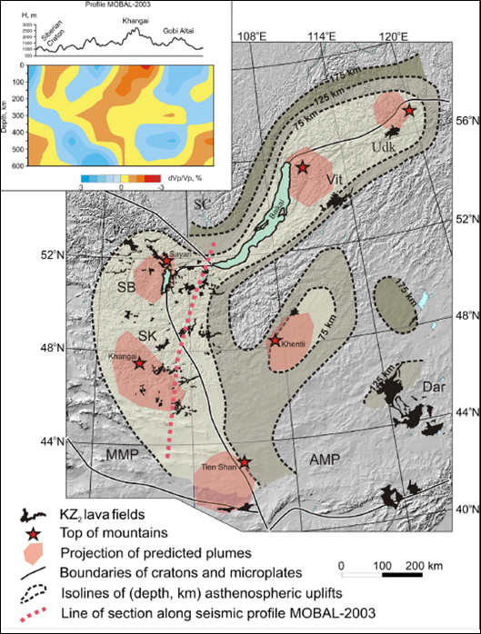
(Yarmolyuk et al., 2015)
Some research papers highlighting the field area include:
Bayasgalan, A. & Jackson, J. A., 1999. A re-assessment of the faulting in the 1967 Mogod earthquakes in Mongolia, Geophysics. J. Int., 138,784-800.
Bollinger et al., 2021. 25,000 Years long seismic cycle in a slow deforming continental region of Mongolia, Scientific Reports, doi:10.1038/s41598-021-97167-w.
Yarmolyuk, Vladimir & Kudryashova, Ekaterina & Kozlovsky, Alexander & Lebedev, V. & Savatenkov, Valery, 2015. Late Mesozoic–Cenozoic Intraplate Magmatism in Central Asia and Its Relation with Mantle Diapirism: Evidence from the South Khangai Volcanic Region, Mongolia. Journal of Asian Earth Sciences. 111. 604-623. 10.1016/j.jseaes.2015.05.008.
Brief Introduction of Sightseeing places
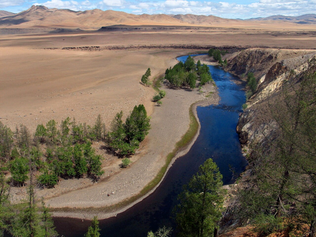
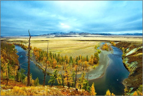
Orkhon River: Orkhon River itself is the longest river in Mongolia with length of 1124 kilometers (709 miles). It originates in Khangai Mountain Range and merges to Selenge River, eventually reaching Lake Baikal.
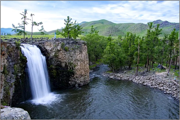
Orkhon waterfall: Orkhon waterfall, also known as Ulaan Tsutgalan stands at a height of 24 meters and a width of 10 meters. It is the widest waterfall in Mongolia. During the Quaternary period, a volcanic eruption occurred at the source of Tsagaan Azarga River. It flew down the Orkhon Valley and created thick layers of volcanic rock which stretched out for several kilometers. The Orkhon River then passed through these layers creating the gorge of the waterfall today.
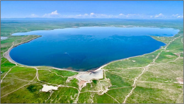
Ugii lake: A freshwater lake and situated in 25km southwest of Ugiinuur soum of Arkhangai province. It precisely lies in the foothill piedmont at the northern flank of the Hangay Mountains and belonged to the Orkhon River basin. This beautiful lake is not that big, covering 2570-hectare land (7km long and 5km wide) with a maximum water depth of 15.3m, and situated at 1337m above sea level. A tributary of the lake is Old Orkhon River, which generates most of the lake water. The north and northwest of the lake is dominated by steppes and forest-steppes. The lake is renowned for its fishing such as a perch, a Luce, 50-80 tons fishes are caught annually.
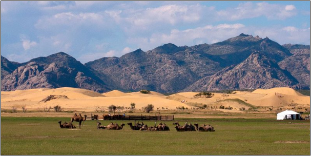
Elsen Tasarkhai: Bayan Gobi is well known and called Elsen Tasarkhai, ‘the sand fracture’, and extend on 80 kilometers in the South of the Khögnö Khan National Park. The main road separates this sand dune into two parts, Mongol Els on the south and Khugnu Tarnyn Els on the north. There are many tourist camps around the sight. Elsen Tasarkhai is surrounded by Mount Khugnu Khan on the north and Mount Ikh Mongol on the south. The sand is soddened under its surface; that allows shrubberies such as willow, elm and dogwood, grow in the area. The area is surrounded by sand dunes, hills covered with rare bushes and a small forest near a river. Together this presents a unique combination of Mongolian mountains, forests and Gobi-type landscape in one location.